Methods and Community
Ground Truth: Validating Satellite Maps in the Field
Every land-cover map rests on points someone walked to. How field campaigns are planned, what a GPS record proves, and why honesty about errors matters.
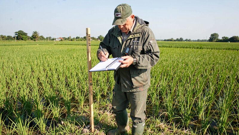
Every map in this magazine eventually faces the same question: has anyone actually walked out there and checked? Ground truth is the discipline of answering yes, of going to the places a satellite has classified and recording what is really there, so that a map's confidence rests on evidence rather than on how plausible it looks on screen. It is the least glamorous part of remote sensing and the part the whole field depends on, because a flood mask, a paddy count or a growth map that survives field checking is evidence, and one that never left the laboratory is a hypothesis. This guide explains how the checking is done in Asian conditions, from sampling design to the notebook.
What ground truth actually means
The term borrows from surveying, where measurements taken on the ground calibrated the aerial photographs above. In modern practice it covers several distinct activities that are worth separating. Validation asks whether a finished map is right, and answers by comparing it against reference points whose truth was established independently of the mapping process. Training data collection gathers labelled examples to teach or calibrate a classifier, a different task with different rules, since the points feed the map rather than judge it. Calibration ties sensor readings to physical units using targets of known properties. The three activities share fieldcraft but not logic, and the classic mistake is to validate a map with the same points used to build it, which tests memory rather than accuracy.
How a validation campaign is designed
The design decides the value of the whole exercise. Points must be sampled according to a scheme that avoids convenience, the road-biased clusters that skew toward accessible land and against the marsh and hill country where maps are weakest. Stratified sampling serves most campaigns: the map's own classes become strata, and each stratum is sampled in proportion or in oversample, so that rare but consequential classes, flooded settlements, say, in the practice of the guide to mapping Asian floods, get enough points to judge. Sample size trades against logistics, and published accuracy carries confidence intervals for exactly this reason. Timing matters as much as placement, because the ground must be observed in the same state the satellite saw: a paddy checked a month after the image shows a harvested field where the map correctly said rice, a trap described again in the guide to rice paddies seen from orbit.
What a field team carries and records
The equipment list is short and the notebook discipline long. A team carries a GPS receiver accurate to a few metres or better, a camera, printed imagery with the sample points marked, and the season's field sheet. At each point the protocol is fixed in advance: stand at the marked location, record the class according to a legend written before departure, photograph the four cardinal directions, and note anything the legend did not anticipate. Date and time go on every record, because the pairing with the satellite's acquisition date is the whole basis of comparison. Metadata discipline is what makes a field point reusable years later by a team that was not there, and the campaigns that skipped it produced archives nobody can now trust.
What Asia adds to the difficulty
Field conditions in the region test every part of the protocol. Monsoon access turns sample points into boat trips, and the seasons when validation is most needed, during and just after floods, are the seasons when travel is hardest. Landscapes are fragmented, so a single thirty-metre pixel can hold a bund, a path, a vegetable strip and a paddy corner, and the honest observation is mixed rather than singular; good protocols record fractions, not forced single labels. Permission and courtesy are practical matters: points fall on private land, farmed ground and village commons, and the teams that explain themselves to the nearest household collect better information, and better photographs, than the teams that do not. None of these difficulties is exotic to regional practitioners, which is precisely why the conference culture described in the guide to the ACRS conference devotes so much corridor talk to field stories.
Alternatives when the field cannot be reached
Not every point needs a visit, and the field has developed substitutes with known limits. Very-high-resolution imagery, interpreted by a trained analyst, serves as reference for classes visible from above, at the cost of inheriting aerial ambiguity. Visual interpretation of time series, an experienced reader tracing a pixel's season curve in the archives described in the guide to free satellite imagery of Asia, substitutes judgement for presence. Citizen-observation platforms and photographs with location stamps offer spot checks, with all the bias of wherever people point cameras. The rule that survives all substitutes: reference data must be more certain than the thing it judges, or it merely adds noise dressed as truth. International working groups under bodies such as CEOS, the Committee on Earth Observation Satellites, maintain the calibration and validation standards that keep national campaigns comparable across borders.
What the numbers are for
Validation ends in a confusion table, a small matrix in which the map's classes meet the field's classes and their disagreements are counted. From it come the accuracy figures a published map should carry, overall and per class, with the class-level numbers mattering most, since a map can be ninety percent right overall and unusable for the one class its users care about. The table is also diagnostic: confusion between two classes points either to a legend that asks the impossible of the sensor, or to a preprocessing step worth revisiting, the chain described in the guide to choosing satellite data. Published honestly, the numbers convert a map from an assertion into a measurement, which is the standing bargain of this discipline and the reason this magazine returns to it, section after section, from the applications of land, water and cities to the methods surveyed in the guide to methods and community.